ADDRESS
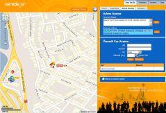
Geocoding
Geocoding is the process of converting text based addresses into geographic coordinates. LocationBox enables you to access a geocoding service via an HTTP request.
Also,
- Provides the most recent city/street information hierarchically
- Completes and corrects the address (postal codes, street names etc.)
- Re-writes the address with the most recent information (changed street names, door numbers etc.) if necessary.
Reverse Geocoding
Reverse Geocoding is the process of finding the closest text based address to a given geographic coordinate. LocationBox enables you to access a reverse geocoding service via an HTTP request.
Also,
- Can bring more than one addresses within the given tolerance (the radius in meters of a circular area),
- Provides the most recent address data.
LocationBox Address Services are used with a Servlet API and return responses in either XML or JSON format.
Watch a video of Address Services > API Page >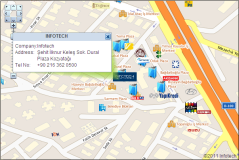
POI
POI (Point of Interest) Search Services
LocationBox POI Search Service brings the nearest POIs to a given point and allows searching by name, brand, distance, category (pharmacies, restaurants, hospitals etc.)
Also,
- With over 1.450.000 POIs, over 480 categories and over 2000 brands LocationBox has the richest POI database in Turkey
- Consistently updated POI database serves the most recent information.
- Returns the results with name, address, telephone number, distance to the given point and coordinates.
- Sorts the results from closest to farthest.
- Provides dynamic content like night pharmacies.
LocationBox POI Search Services are used with a Servlet API and return responses in either XML or JSON format.
Watch a video of POI Search Services: Search by category > Watch a video of POI Search Services: Search by keyword > Watch a video of POI Search Services: Search for night pharmacies > API Page >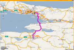
ROUTE
Route Finding, Distance/Duration Cost Calculating Services
Calculate the fastest or shortest route for given two points with LocationBox Route Service. Optimize the route by giving additional points.
- Calculate the most optimized route (Shortest Path) between two given points.
- Calculate route for points additional to start and end points (Traveling Salesman Problem).
- LocationBox Route runs on Turkey's widest and most up-to-date road network measuring over 400.000km including highways, streets and all village roads.
- Route calculation using road or vehicle specific constraints (sea lines, toll roads, trucks etc.).
- Returns the calculated route with distance and duration information, either as drawn on map or as a set of directions.
- NEW! Estimated time calculated with real time traffic data. See Route Service API for details.
LocationBox Route Services are used with a Servlet API and return responses in either XML or JSON format.
Watch a video of route services > API Page >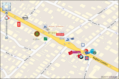
MAP
Map Services
Visualize your data, tune your web applications with LocationBox Map Services' wide range of functions and most recent map data.
- Use most detailed and most recent map data.
- Display POIs of over 1300 brands with their logos on your maps and your applications.
- Create layers and visualize your data.
- Mark your own important points, areas or create lines.
- Use LocationBox Map's many other features to provide a rich user experience to your customers.
LocationBox Map Services are used with a Servlet API and return responses in either XML or JSON format.
Watch a video of map services > API Page >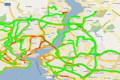
TRAFFIC
Traffic Information Services
Add traffic info onto your maps with LocationBox Traffic Services.
Be the first one to know where the traffic jam is. Spread the news.
See the JavaScript API for more information.
- LocationBox Traffic Info is instantaneous.
- LocationBox Traffic Info is being refreshed every minute using Floating Car Data method.
- Includes all the motorways in Turkey.
- Covers 12.213 km of real time road traffic data in Turkey.
- Covers 1458 km of real time road traffic data in Istanbul including motorways, main arteries and bridges.
- Covers 1880 km of real time road traffic data in Ankara.
- Covers 737 km of real time road traffic data in Izmir.
- Available all cities in Turkey.
LocationBox Traffic Information Services are used via JavaScript API.
JavaScript API > Demo Page >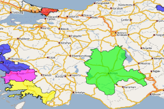
ANALYSIS
Analysis Services
Create colored analyses or pie analyses using LocationBox Analysis Services.
See the JavaScript API for more information.
- Use geographic bounds. (il/ilce/mahalle/bolge)
- Create infinite number of analyses using infinite number of parameters.
- Visualize your data with infinite number of colors and shades.
- Very easy API enables you to create your analyses in no time.
- Use LocationBox Analysis Services to provide rich demonstrations.
LocationBox Analysis Services are used via JavaScript API.
JavaScript API Demo Page For Color Analysis > Demo Page For Pie Analysis>
USER DATA
User Data Services
LocationBox user data service allows store your own points, and the zones.
Also,
- You can show your points and regions on LocationBox Map. (using createLayer JavaScript function)
- You can analyze your points and regions with using user data service.
LocationBox User Data Services are used with a Servlet API and return responses in either XML or JSON format.
AddUserPoint API > AddUserRegion API > JavaScript API >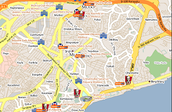
CAMPAIGN
Dynamic Information Services
View information about the latest campaigns of most popular brands (Electronics, cosmetic, etc.)
See the Add Campaign for more information.
- Sort and display campaigns based on your gps location
- Campaigns can get by categories.
- You can find nearest campaigns.(CampNearCampaign Service)
- View the details of the campaign POIs.
LocationBox Campaign Services are used with a Servlet API and return responses in either XML or JSON format.
API Page> JavaScript API> Demo Page For Add Campaign>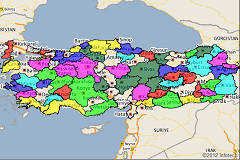
DEMOGRAPHY
Demographic Services
Use various types of demographic information up to date.
See the Demographic Info for more information.
- Demographic informations can be displayed as education, population, vehicle ownership, such as housing types.
- You can use geographic bounds. (il/ilce/mahalle)
LocationBox Demography Services are used via Servlet API.
API Page>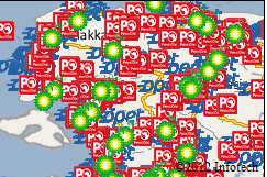
DYNAMIC INFORMATION
Dynamic Information Services
Use various types of dynamic information up to date.
See the Dynamic Information for more information.
- View information about the latest Fuel & Park Prices.
- You can use geographic bounds. (il/ilce/mahalle)
- Sort and display Fuel & Park Prices based on your GPS or network location.
LocationBox Dynamic Information Services are used via Servlet API.
API Page>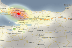
HEATMAP
HeatMap Service
Create heatmap analyses with using POI types and your user points.
- Use geographic bounds. (ulke/il/ilce/mahalle/yol)
- You can use POI data types. (brand/category)
- You can use your points with UserPointList
LocationBox HeatMap Service are used via JavaScript API.
JavaScript API> Demo Page For Add Heat Map>